موقعیت یابی برای ناوبری ساحلی (Positions)
منبع : حمل و نقل دریایی
موقعیت یابی برای ناوبری ساحلی (Positions)
Positions
Home
Nav.
course Sailing Greece
Turkish Coasts Yacht
charter Gulets
![]()
![]()
![]()
![]()
![]()
Longitude and latitude
The earth can be regarded as a spherical object, and
since we're dealing with a 3-dimensional shape we need coordinates of a
different form than the usual x- and y-axes. Though adding an extra
z-axes would make sense for submarines, we will most likely be found on
the surface of this sphere while using another system of coordinates,  that covers our planet with
imaginary lines called meridians
and parallels, see figure 1. All
these lines together provide the grid which enables us to describe any
position in longitudes and latitudes.
that covers our planet with
imaginary lines called meridians
and parallels, see figure 1. All
these lines together provide the grid which enables us to describe any
position in longitudes and latitudes.
The obvious place to divide the Northern and Southern
Hemispheres![]() was the equator. But the division of the Eastern and Western
hemispheres was the source of much political turmoil. Greenwich (Great
Britain) won, placing for example The Netherlands in the Eastern and
Ireland in the Western Hemisphere.
was the equator. But the division of the Eastern and Western
hemispheres was the source of much political turmoil. Greenwich (Great
Britain) won, placing for example The Netherlands in the Eastern and
Ireland in the Western Hemisphere.
It takes the earth 24 hours for a full rotation of 360°. Thus, every hour we rotate 15° longitude, see figure 2.
When it is 12:00 UTC (international standard time) - anywhere in the world - it is 12:00 Local Time in Greenwich and 24:00 Local Time at the other side of the planet: 180° E or 180° W: the date line. Crossing this special meridian changes not only the hour but also the date.
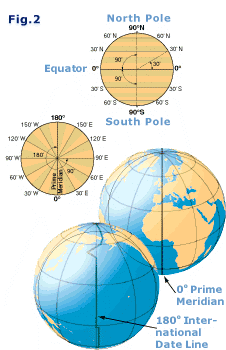 The North Pole has a latitude of 90° N and the South Pole
90° S. The meridians cover twice this angle up to 180° W or E.
The North Pole has a latitude of 90° N and the South Pole
90° S. The meridians cover twice this angle up to 180° W or E.
Meridians
converge at the poles, whereas parallels run parallel to each other and
never meet. All meridians and the equator - the biggest parallel - form
great circles, and the remaining
parallels form so-called small circles.
A great circle divides the earth in two exact halves.
In figure 3 the position of Boston in the United States
is shown using latitude and longitude in degrees, minutes and seconds:
42°
21' 30" N , 71° 03' 37" W
Most sailors will actually notate seconds in metric
fractions of minutes:
42° 21,5' N , 71° 03,6' W or
42° 21.5' N ,
71° 03.6' W![]() , see the notation
style guide
, see the notation
style guide
On small scaled charts we want to be accurate within one minute or one nautical mile. On larger scaled charts the accuracy is more likely to be within a tenth of a mile (a cable).
If the earth were a perfect sphere with a circumference
of roughly 40000 kilometres all great circles - meridians plus the
equator - would have the same length and could be used as a distance
unit when divided  into
360 degrees, or 360° x 60' = 21600' minutes. In 1929, the international
community agreed on the definition of 1 international nautical mile as
1852 metres, which is roughly the average length of one minute
of latitude i.e. one minute of arc along a line of longitude (a
meridian).
into
360 degrees, or 360° x 60' = 21600' minutes. In 1929, the international
community agreed on the definition of 1 international nautical mile as
1852 metres, which is roughly the average length of one minute
of latitude i.e. one minute of arc along a line of longitude (a
meridian).
Or to put it shortly: 1 nm =
1'
We are now able to describe any position in latitudes and longitudes. Moreover, we can state the distance between two of those positions using nautical miles or minutes. All we need now is a proper way to define speed. For that, sailors use knots, the number of nautical miles an hour.
RYA & ASA sailing schools
To put this navigation course into practice a Royal Yachting Association or American Sailing Association approved
sailing course is recommended. Sailing schools in
Greece and Turkey for:
RYA competent crew
RYA day skipper
(non-tidal)
RYA coastal skipper (non-tidal)
ASA basic coastal cruising (103)
ASA bareboat
chartering (104)
ASA coastal navigation (105)And
the most enjoyable way to learn how to sail is by combining such
courses with a yachting vacation in Greece or Turkey. Ideal areas for
sailing courses are the Saronic
Gulf near Athens and the Ionian
Islands to the west of Greece, which provide reliable and
gentle winds, dolphins and ancient Greek monuments and temples.
A little History
Mariners during the 15th century relied on charts called
"portolans" to assist them on their voyages. Portolan comes
from the Italian word portolani![]() , which were medieval pilot books.
, which were medieval pilot books.
The portolans contained maps of coastlines, locations of
harbours, river mouths, and man-made features visible from the sea.  They were a compilation of centuries of seafarer
observations. As sailors' skills improved and the use of the compass
was more widespread, portolans improved in accuracy.
They were a compilation of centuries of seafarer
observations. As sailors' skills improved and the use of the compass
was more widespread, portolans improved in accuracy.
Also Columbus![]() used these portolans on his journeys. Portuguese chart makers added the
meridian line, a point useful for latitude sailing as well as for
navigating solely by compass. A geographic feature could now be located
through the use of its distance in degrees of latitude from a ship's
point of departure. Note that the use of latitude and longitude was
understood since the time of Ptolemy
used these portolans on his journeys. Portuguese chart makers added the
meridian line, a point useful for latitude sailing as well as for
navigating solely by compass. A geographic feature could now be located
through the use of its distance in degrees of latitude from a ship's
point of departure. Note that the use of latitude and longitude was
understood since the time of Ptolemy![]() , the second century CE.
, the second century CE.
During the fifteenth century Portugal led the European
world in sea exploration. The golden age of discovery for Portugal
lasted almost a century until the Dutch eventually seized their trade
routes from them.
As we move to the next chapter of this course we
enter the sixteenth century when the Mercator chart was invented.
Glossary
Parallels: Circles parallel to the equator, ranging from 0° to 90° N or S. Only the equator is a great circle.
Meridians: half-circles converging at the poles, ranging from 0° to 180° E or W. Each pair of opposing meridians forms a great circle.
Prime meridian: 0° or the Greenwich meridian which - together with the date line meridian - divides the Western and Eastern hemispheres.
Great circle: The intersection of a sphere and a plane that passes through the sphere's centre.
Small circle: The intersection of a sphere and a plane that doesn't pass though the sphere's centre.
Time zones: By convention 24 zones, each 15° longitude wide. Hence, noon at Greenwich gives midnight at 180° E.
GMT, UTC, Zulu: The outdated accronym GMT (Greenwich Mean Time) is roughly the same as UTC or Zulu, and is also the local time at Greenwich when daylight saving isn't used. Note that UTC is an atomic time scale which only approximates GMT, so best to use the modern term “UTC”. Antonym: Local time elsewhere. For example, local time in Athens = UTC + 2.
Date line: The 180° meridian which extends from or is opposite to the prime meridian. Here, not only the hour changes when crossing the meridian, but also the date.
Latitude: Position property defined by the number of degrees north or south of the equator, varies from 0° to 90°.
Longitude: Position property defined by the number of degrees east or west of the prime meridian, varies from 0° to 180°.
Position: Latitude first and longitude second. For example: Athens in Greece 37° 58' N , 23° 43' E.
Nautical mile: One nm is one minute (') on the vertical scale on the chart. 1' equals 1852 metres. Nautical miles are divided into 10 cables.
Knots: Nautical miles per hour.
